Sunday, 10 November 2013

Hold it!

Have you ever wondered how your holiday jet is able to fly thousands of miles with no sight of the ground, descend into the clouds, manoeuvre around, hold, approach the airport and pop out of the bottom of the clouds at exactly the right place, speed and height to land?

The Buckeye VOR DME C hold and approach
pattern used in our training and tests
You might think GPS has something to do with it, and computers and of course autopilots. But no.

Instrument approaches pre-date all of those, and the essentials are simply the basic flight instruments, a nearby radio beacon, a radio instrument to pick it up and a printed chart of the approach procedure known as a plate.

And a lot of practice.

On the right you can see an approach plate, in this case to Buckeye Municipal Airport which is a tiny little public strip near our old base in Goodyear. This is a reasonably complicated plate, and there is a lot of jargon, but it is not as bad as it first looks.

The main part is simply a drawing of the procedure seen from above. It's not drawn to scale, but just gives the general picture. You arrive from wherever you like and fly to the little round symbol in the middle, which is a radio beacon. Then, you fly round and round the racetrack pattern until you are ready to approach and land. Next, you fly off five miles to the north west, descend a bit, turn around, descend a bit more, go back over the beacon and finally descend and head in the general direction of the runway on the right.

Underneath is a side view of the same approach, you can see that each part has a specific altitude. There is also a table that give the lowest altitude you are allowed to fly to as you approach the airport. If you still can't see the runway at this point, you must do the missed approach procedure. In this case, turn around to the left, climb, go back to the beacon and start flying round and round again.

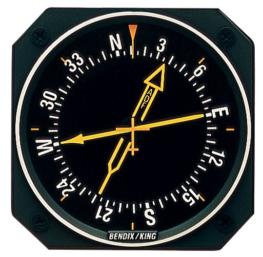
A radio magnetic compass. This model has two
needles, which track two different kinds of
radio beacon. Here, the plane is heading north. There
is a beacon off to the left and slightly behind, and another
ahead and just to the right.
The clever part is this whole procedure is defined and flown using just one radio beacon. In the aircraft the we have an instrument called a radio magnetic compass (RMI). It has a needle that simply points to the beacon, and around the outside is a compass card that rotates to show which way the plane is heading. Add in a stopwatch, and provided you remember to reset it every time you cross the beacon you can now pinpoint your position.

Sounds easy enough, but regular readers will have already guessed the next part... it's not that simple. Firstly, we are flying a plane with sole reference to the instruments, taking care of radio communications and performing various check-lists at the same time. Secondly, interpreting these basic instruments is not easy. And thirdly there is the wind to make the whole thing even more confusing.

Probably the most difficult part of the procedure is entering and flying the hold — the little race track pattern in the middle. A hold is simply a way to get an aircraft to stay in the same place for a while (aircraft, unlike every other vehicle ever invented, are physically unable to stand still.) It's something we are practising a lot at the moment.

Three ways to enter a hold, depending on
the direction you approach the beacon.
The hold always starts at a radio beacon, and it is defined by the compass direction (track) of the straight part heading towards the beacon. This has to be flown for a specific amount of time, usually one minute. Then the pilot turns — usually right — using a standard rate turn (three degrees per second), flies on the opposite heading for a minute. Another turn to the right and in an ideal world they are back on the inbound track one minute from the beacon.

The wind can make a right mess of this. If there is a cross wind component, you can correct for it on the way inbound by flying whatever heading keeps the needle pointing to the required ground track (the one on the plate). But to do this, you do need to get onto the correct track pretty early so you have time for the trial-and-error procedure required to find the heading. Confused? See blowing in the wind.

On the other three parts of the hold — the outbound leg and the two turns — you have no beacon to track to and hence no point of reference. In theory, if you needed a certain amount of correction on the inbound leg, say 5 degrees left, then you should need three times this amount on the outbound leg but in the other direction — 15 degrees right. This is because the wind is blowing you off course during both turns as well as the outbound leg, a total of three minutes of wind needs to be accounted for.

An early attempt at the Buckeye hold on a windy day.
You can see the strange shape of the turns caused
by the cross wind, and also where I got confused
and applied the wind correction the wrong way on one
of the circuits. The red blob is the beacon. The
wind appears to be from the south east here.
Head or tail wind components muck up your timing. In order to get the required one minute inbound, you have to adjust your time outbound. Again, it is trial and error though you do have some idea what to expect before you start from the winds aloft forecast. These are the purple numbers I have scrawled on the plate.

What you should end up with, after a few circuits, is a kind of egg-shaped pattern with the into-wind turn being tighter than the down-wind turn, and the outbound leg skewed to connect them together. What we tend to end up with is a right mess that looks like someone just dropped their knitting.

There is a lot more to it than this... there is the entry to the hold to get right, there are various 'gates' that are used to monitor your progress around the pattern and so on. I won't bore you with the whole lot, if you would like to find out more, here is a good explanation.

I have a couple more lessons to practice this on Monday before yet another progress test. Following this I have one final solo. That will be the last time I fly a single engine aeroplane on the course, as the following week we start on the Seneca. Apart from having two engines, it is fitted with retractable gear, variable pitch propellers, superchargers and flies about 50% faster than the Warrior. Twice as many knobs and levers and a lot less time to think!

I am also doing the APS upset recovery training course next week which should be an eye-opener. They use aerobatic Extra 300 stunt planes to explore all sorts of crazy flight attitudes and conditions from inverted to spins and of course how to get out of them.

It's going to be quite a week.

The next challenge; getting to grips with the Piper Seneca

Friday, 1 November 2013

Cross Country Qualifier and Movember

Cross Country Qualifier

On Tuesday I was able to squeeze in my cross-country qualifier when a schedule change unexpectedly freed up a day. There's a massive amount of planning required as it essentially counts as three separate trips, so I completed as much as I could the night before and caught the first bus at 4.30am to complete the rest at school.

Tuesday was far from a typical Arizona autumn day — in fact it was more like a typical UK autumn day. Temperatures were relatively low which is a good thing, but so was the cloud which is not so great. At times the cloud base was forecast down to 6000' or even 4000'.

But the interesting part was the winds, which at 6000' were forecast at 24 knots (about 28 mph) and the surface winds looked strong and gusty to the south. A few months ago I would have not attempted to fly. I knew it would be challenging, but I was (just) within my limits on all the forecasts and provided there were no delays, I would be technically good to go. All I had to do was persuade the duty instructor! I finally succeeded, but it took half an hour and put me even closer to the out-of-limits surface winds forecast at Ryan.

There was no chance of cruising at my planned 8500' on the way to Ryan due to the cloud, and even 6500' was close. I was using the flight following radar service as usual, but as I got near to Ryan, Tucson Approach started to direct me to different headings and altitudes (radar vectoring) rather than just monitoring me. That was new.

A Cessna landing at Ryan
As I approached to land, Ryan tower reported the wind at 21014KT20 which in English means 16 miles per hour gusting to 23 miles per hour and coming from the south-south-west.

The runways at Ryan point 240 degrees or south west — 30 degrees off the wind direction — meaning I had a 10 knot cross wind and a 20 knot head wind. Bang on my maximum. Happily though the landing went really well on the first attempt, and I quickly refuelled and got back into the air before the winds got any worse, fairly confident that conditions were better to the north.

The next leg out to the west was even more interesting. The strong cross winds meant I had to take some dramatic correction angles — up to 25 degrees — which looks very odd. You point the plane one way, and actually fly in an entirely different direction! As I approached the familiar Table Top Mountain, there was a series of text-book wave clouds, long parallel sausage shapes.

Unfortunately they were well below my altitude, forcing me to descend to about 4000' to get clear below. I radioed Albuquerque Centre to let them know I was descending, and they promptly terminated my radar service, which was not the outcome I was looking for! Not their fault though, below about 5000' they simply can't see us on their radar.

A TCAS (traffic collision avoidance system) similar
to the type not fitted in our aircraft.
As I turned north again towards Goodyear, the weather steadily improved and the winds dropped making the rest of the flight uneventful. I felt quite nostalgic to be back at the now quiet Goodyear. Time for a quick lunch break, more fuel, and back in the air for the final leg.

This too was a busy flight. The cloud had pushed everyone down to similar altitudes making the practice areas very busy. Without any technical wizardry to spot other aircraft in our vintage Warriors, we rely on look out and radio calls. 4500' was just so popular that in the end I chose to fly an unconventional 4300' just to give a bit of extra safety margin and was scanning like a crazed owl.

After 300 miles, landing at three airports and five hours in the air, I was back at Falcon, tired but happy. Job done. Strange to think that, professionally, that was my last ever solo. If I didn't fly privately I could work until I was 65 and pilot an aircraft alone again.

Movember

A Hair-O-Plane, yesterday.
This blog has had — amazingly — over 21,000 hits to date. Clearly there are a lot of people out there who enjoy reading it, not just friends and family. I'm hoping to persuade you all to part with just a little tiny bit of your hard earned cash for a very good cause; it's Movember!

Yes it's that time of year when we grow ludicrous facial hair in an attempt to raise some cash for vital research into key men's health issues including prostate and testicular cancer.

I know, growing a moustache hardly compares to running a marathon or doing a six-minute-mile in Death Valley in midsummer dressed as Darth Vader, but hey it's not as easy as it sounds.
  1. It's against the school uniform code
  2. I am going to look stupid for a whole month
  3. My wife hates the idea (she will be paying for me to shave it off)
  4. It will probably be ginger
So have a heart and bung me and my team a couple of pounds. For each £100 I raise I will release a photo of my progress. You have been warned.

Go on, it only takes a moment. Thank you!

Monday, 28 October 2013

Copper State Fly-in

All my solo navigation flights to date - it's fair to
say we are quite familiar with the local area now.
On Friday I flew and passed progress test three, which went really well. It is a visual navigation test based on "dead reckoning", meaning that you plan the route before hand on the chart, figuring out all the timings and headings in advance.

If you do your maths right, fly carefully and have an accurate wind forecast you should find yourself at each planned point at exactly the planned time. This rarely happens. But on Friday it all came together, I don't think I was ever more than a minute or a mile out even on the diversion leg, which is planned in the air.

After this, we did a practice forced landing from a simulated engine fire onto a little dirt strip, and a couple of "touch and go" landings at a different airport before returning to base. Everything went smoothly, and the few small errors I did make must have gone unnoticed as I was given top marks for the test. What a contrast to progress test two!

This week is looking very slow on the training front while I wait for the others in the group to pass their tests (I am keeping everything crossed hoping we will be home for Christmas). But I should be able to fly my cross country qualifier. This is a minimum 300 mile solo flight with full landings at two other airports. It will be a long day but I think a lot of fun as well. It will be pretty much the last solo flying I will do, as we don't get to fly solo in the twin engine aircraft sadly.

In other news, British Airways have just re-opened their Future Pilot Program for round three. If you or anyone you know would like to apply, don't hang around as they generally only give you a few weeks to apply. It's good news for us as well, it seems the demand for pilots to fly the new A320 fleet out of Gatwick is greater than expected and the jobs are there waiting for us next year.

Copper State Fly In


Four planes line up for a formation takeoff, while the
Stearman and its baby replica (below) show off
Last week, on pain of torture, we students were strictly forbidden to fly anywhere near one of our neighbouring airports, Casa Grande. The reason? Something called the Copper State Fly In was being held there, one of the largest in the US. What is a fly-in exactly? I wasn't sure really, but I was willing to find out so a friend and I decided to drive down and see what was happening.

What we found was basically organised chaos. The entire apron, and several dirt lots, were completely full of parked aircraft of all types. Some of them were clustered in groups, such as the ultralights and the kit-built planes, while others seemed random. If there was a pattern, it seemed to be the more interesting your plane, the nearer you could get to the middle where the action was.

Milling around the area were hundreds of people admiring the machinery and chatting to the owners. Planes were constantly arriving and departing from the single, uncontrolled runway. Some just flew circuits but others showed off their formation flying or did low passes over the runway. Planes constantly taxiied in and out of the busy apron, and how no body got minced by a prop I do not know. This sort of thing would never be allowed in the UK!

The awesome Lightning kit-build two seater. I want one!
There was a strong show from the experimental and home-built categories, a popular and affordable option for private ownership, if you have the time and skills. These are certainly not the shonky box-like death traps you might imagine, but often very modern, high performance composite aircraft with advanced avionics. Take a look at the Lighting for example - it can cruise at 140 mph while burning 5 gallons per hour and is fully aerobatic. Not bad for something you can knock up in your garage in a few hundred hours.

The Commemorative Air Force museum also put on a good show with an impressive number of still-flying and very highly polished WWII era planes including a B25 twin-engine bomber that was so shiny you could see your face in it.


Another kit aircraft, the Cozy has the engine and prop at the back, the
elevator at the front and the fins and rudders on the wing tips.
Either a genius design or plain contrary I'm not sure...
Little and large!


Someone has got far too much time on their hand for polishing.

Sunday, 20 October 2013

Two Phoenix Transitions

The flight line at dawn - Red Mountain in the background

Phoenix Transition 1

As predicted, our move to Falcon Field over on the east side of Phoenix has not gone entirely smoothly. The operation here is cursed with a horrendous computer system for planning and dispatch that is the source of a lot of stress, maintenance is a perennial problem and I don't think the staff were quite ready for the extra workload of 45 extra students, 10 instructors and two more aircraft fleets.

Despite the wrinkles, we are making slow but steady progress and getting familiar with the area. I have been lucky with another excellent instructor who also happens to be an examiner and hence knows exactly what we need to learn for the tests.

Yes, another test is looming — progress test three — due around the end of this week. This one is a navigation test, where a flight is planned and flown on visual 'dead reckoning' techniques, no radio aids or GPS allowed!

Falcon Field - our new home base
At some point en route the examiner will call for a diversion. We then have a few minutes to plan a new leg in the air, figuring out the distance, time and heading (accounting for wind), altitude, fuel burn and arrival time. Arrival at the diversion point must be within three minutes of our stated time, which is actually a lot more generous than it sounds. The hardest part is flying the aircraft competently and keeping a good lookout while our head is down and hands are busy figuring out all this stuff.

It is also a dead-cert that at some point the engine will "catch fire", and we will need to execute an emergency descent to a forced landing on a suitable spot with all the associated checks. A forced landing in a small plane is really no different to a normal landing in a glider, except the glide ratio is a lot worse and there are no air brakes, so good judgement of our height relative to our landing spot is needed. We don't actually touch down in the desert of course, once the examiner is happy the engine will magically restart and we "go around" which is simply a full-throttle best-climb get-the-hell-out-of-there manoeuvre.

Airspace


Phoenix has some of the busiest skies in the world. Of course, there are commercial jets in and out of Sky Harbor, one of the world's busiest airports. But the good weather and large distances attracts lots of general aviation (small private planes) and skydivers. Then there are extensive military operations, helicopters, some gliding and ballooning and of course heaps and heaps of student pilots. One of the ways this mess is kept in some sort of order is through classes of airspace.

An airspace is simply a defined region of space that has special rules attached to it. They may start at the surface or they may be suspended in mid air. Their boundaries are clearly shown on our maps, but sadly no one has yet worked out a way to mark them in the sky so these vital boundaries are totally invisible to the pilot.

Some types of airspace are strictly off-limits to us, and entering them even if briefly and accidentally has serious repercussions. Prohibited and active restricted areas fall into this category, as does class B airspace such as the one protecting the busy Skyharbour international airport.

Others we can use, but only if we follow the correct procedures. Our own base for example is a class D airspace, which means we can only enter if we are in communication with the control tower.

Airspace around Falcon Field


There is a lot of other airspace near Falcon field. Just to the west we have Sky Harbor's class B starting at 2700'. Our airport is at 1400' and we fly the pattern at 2400' so this does not give a large margin for error.

To the south we have the busy Phoenix Mesa Gateway airport which operates regional passenger jets. It has not only a class D zone to 3900' but also an instrument approach, which means large, fast traffic will approach the airport through 'our' practice area without looking where they are going.

Just south-east of this is restricted area R-2310 which for years lay dormant, but is now used for testing unmanned military drones. Let's not tangle with those!

Above all this, between 5000' and 10,000' is a huge aerobatics box used by a local company for upset recovery training. We will be doing this course soon, which is going to be an amazing experience, so I'm not moaning too much about that one.

Finally, a little further south we have some very busy parachuting areas and some radio beacons where a lot of people practice holds and instrument approaches. These latter two are not strictly airspace, but definitely best avoided.

Phoenix Transition  2


Sky Harbor seen from the transition
Phoenix Sky Harbor has its three runways running east-west, and with its extensive airspace and constant traffic it effectively cuts the entire area in half making it very difficult and long-winded to fly from the north to the south of the city and visa versa.

To address this problem there is a special route called the Phoenix transition. This allows small aircraft flying visually to enter the class B airspace and fly straight across the ends of Sky Harbor's runways.

Although this sounds balmy, flying at right-angles over the middle or ends of a runway is fairly safe as all the traffic taking off and landing will be well below you. You will only be in anybody's way if they make an early go-around or missed approach, meaning they didn't like their approach to land and want to climb up and try it again. Plus you have air traffic control keeping a close eye on things for you.

Still, it is not something to undertake lightly and student pilots are not permitted to try it. So it was a nice surprise when our instructor decided to shoot the transition during a lesson last week. It was quite an experience trundling overhead down-town Phoenix and one of the world's busiest airports, the heavy traffic passing just below.

Downtown Phoenix, with the Chase Field baseball
stadium in front, roof open.


Wednesday, 2 October 2013

Goodbye Goodyear

The school parking ramp looking is deserted as the planes
are shuttled over to Falcon Field
No, sadly I am not headed home just yet, but we are saying our goodbyes to Goodyear municipal airport. After nine years, the flight school is leaving and relocating to Falcon Field way over on the other side of Phoenix.

We have mixed feelings about the move; it seems to be due to corporate machinations rather than anything aviation related, and it is a shame to lose such a great base just for financial reasons. The new base is massive with lots of flight schools operating from a large new building, and the airspace around the twin-runway airport is positively buzzing with students from around the world. To move to a busier and therefore arguably less safe airspace does not make sense to me, but what do I know? I am just a lowly cadet.

Unfortunately my instructor has resigned (again — I hope I don't get a reputation) so it looks like there could be some delays ahead. In anticipation I have been packing in as much flying as I can in the last fortnight. As a result I am nearly two-thirds of the way through the course.

I am now just shy of the 100 hours milestone — one of several points in a pilot's career at which he is at the greatest risk statistically. Why? I suspect it is the point that you really feel that you know what you are doing, but you are very wrong! I will try to remember that I am still very much a beginner.

Today I flew the last of three land-away double solo trips. It was a fiendish route with a ridiculous number of turn-points several of which were difficult to spot. But it went really well, and it was a joy to fly in the smooth air of autumn now the temperatures have reached sensible levels and the turbulence has abated. The cafe at Chandler Municipal Airport is now my favourite, and I hope that we will be able to make it a regular stop after the move. I think Goodyear will also be a regular stop, one tinged with nostalgia for students and staff alike.

Until next time. Goodbye Goodyear!


Saturday, 21 September 2013

Training wheels are off

So much as happened since my last post I don't really know where to begin.

Yesterday I flew and passed my second progress test, although only just. Luck was not on my side as I had the schools most famously strict examiner and a nasty hot, rough afternoon to fly in. I didn't do myself justice but at least I got through.

So after feeling a bit down about the test, it was wonderful to fly today's solo navigation flight which could not have been more different. It was a calm, mild day (only 32C), I was assigned one of my favourite planes. The route was familiar but also had some longer legs which allow just a little time for sightseeing and contemplation.

For us, the person in the right seat is either an instructor or an examiner which means stress, concentration and hard work. It's great to get up alone and be the master of your own schedule. Every check feature and turn-point appeared at the right time, in the right place just as my planning said it would. Visibility was almost unlimited at 7500', the desert was looking majestic and I could look down at Phoenix far away festering under a yellow sheet of its own pollution. Once back at base, I threw in three glide circuits just to check I had not really forgotten how to glide and land properly, and they too went perfectly. If only I could have flown like that yesterday; c'est la vie.

Solo navigation


Much of our time now is spent on solo navigation routes. These are flown with good old fashioned "dead reckoning" techniques as used by sailors for centuries, with a bit of help from radio navigation aids. We do have some very nice GPS units in the planes which will navigate for you, but frankly that is just cheating.

The routes typically take about two hours, and the school supplies a list of the points they would like us to fly to. The rest is up to us, and there is a great deal of planning and paperwork required before we can actually fly.

The night before, we can mark the route on the map. This is not simply a line, but all the information we need for the flight. There will be checkpoints chosen so we can monitor our progress, drift lines to help assess wind, information on altitudes, headings and times to fly for each leg, radio frequencies to use, airspace to watch out for and so on. This is the most time consuming part.


The next job is the flight log, which is a kind of manual spreadsheet. Starting from the bearings and distances from the map, we have to work out what headings and times to actually fly. This does not sound too hard, but there is a lot to take into account; magnetic variation and wind affect the heading (which way you point the aircraft to achieve a particular direction on the ground). Wind, pressure and temperature all affect your ground speed which can be quite a bit different from the speed indicated in the aircraft. The flight log comes along with us and gets scrawled on extensively during the flight with timings, frequencies and any other information we wish to record.

Then there is the flight plan form to complete and file over the phone, the mass and balance to calculate, the risk assessment to complete and the all-important weather briefing. All this gets presented to the duty instructor to pick holes in, who will grumble a bit and finally authorise the flight and endorse our logbook. Finally there is just the dispatch log-out sheet and the aircraft tech log to complete. For every hour flying, there is probably another hour of paperwork to go with it.

Just some of the paperwork for tomorrow's flight

Flying the routes is very busy at first. In addition to the usual aircraft handling and numerous check lists we are navigating using the planned data and the map, trying not to get lost and fanatically looking out of the windows like a crazed meercat for other planes.

At the same time we need to talk to a lot of different people on the radio. We have two radios, each of which can be tuned to two frequencies and flipped between them. Even so, there are times when I wish there were three.

We will always be tuned to a frequency for the local traffic so we can report our position and listen to where everyone else is. The flight plans we file have to be activated by radio. If we are lucky, Phoenix Sky harbour or Luke Air Force Base will give us a radar service called "flight following" where they keep an eye on us and maybe warn us about traffic and other hazards. Usually though, they cannot be bothered. We need to talk to air traffic control when arriving and departing, and finally most airports have a recorded weather/information service we are required to listen to.

After all this planning and flying, we have a bit of down time then it is time to start all over again. In this case, doubled...

Tomorrow is another big day; my first land-away solo. This time the route heads way down south out of familiar territory and all the way to Tucson. Here I must land at a strange airport, run by mean and scary controllers (maybe), figure out how to refuel the plane and myself, then fly a different route back. Twice the paperwork yes, but I'm sure more than twice the fun.

Sightseeing


After a wonderful three-week visit by my wife, where we squeezed in all sorts of tourist stuff around my flying schedule, she had to go back home last week to work in rainy old England. Sounds very unfair I know, but I'm sure the boot will be on the other foot in a few years time.

I will leave you with some pictures of our travels around Phoenix, Tucson, Patagonia and the surrounding countryside. Until next time.

The red rocks of Sedona

Scottsdale
The roof opens at the immense Chase Field ballpark (we lost again)
Some gorgeous girl I met at the baseball getting into the local culture.
Cactus flowers for lunch
Ten engine madness at the Pima air museum
Worlds smallest flying aircraft - six foot wingspan.
Epic Saguaro cactus near Lake Pleasant
There's tons more but I would bore you and it's dinner time. Tomorrow; Tucson!

UPDATE 21/9/13. The trip to Ryan Field near Tucson went great once I'd finally waded through the sea of paperwork. There proved to be at least six of us doing the route today so there was a sort of relay breakfast going on at the excellent airport cafe. On the return flight I managed to get the thing up to 8500', which is pretty good for these temperatures. Nice and cool up there, great views and hardly any traffic. A couple of times I made the classic error of talking on the wrong radio, with the consequence that Tucson approach now think I am an idiot. Oh well, they are only the second largest airport in Arizona. I should apologies to the radar guys for saying they can't be bothered with us. They were great today, covering me for the whole trip and handing off seamlessly between centres. Incredibly actually I remembered to open and close both flight plans - I must be getting the hang of this flying lark now. Tonight we are heading to the 24th Annual Goodyear Oktoberfest held in one of the maintenance hangers by the German Air Force. 1000 people are expected and the band and beer are flying in from Germany. Prost!

Tuesday, 3 September 2013

Fly by night

The flying lessons are in full swing now. I have a packed schedule; often my flying buddy and I have two missions per day, many of them solo.

Our instructor recently left the school, lured by a job flying small twin-piston passenger planes in Florida and our new instructor — by popular opinion one of the best — is pushing us hard. She's excellent but does have a bit of a penchant for very very early mornings. Well, it does get us out of the heat (it's only 30 degrees at 4am, but still 40 at 4pm) and early morning are all part of the airline pilot experience.

Better still my wonderful wife is over on an extended visit. Life is good!

Seeing where you are going


There are basically two types of flying — visual and instrument. When flying visually you navigate, avoid traffic and handle the plane based 90% on what you can see outside the window. Visual flying is what small aircraft, gliders and private pilots do pretty much the whole time.

To fly visually you obviously must be able to see where you are going. We have some fairly complex requirements called the Visual Meteorological Conditions, and these bascially specify how far you must be able to see and how far away from clouds you must stay.

If you do not meet these requirements you are by definition in Instrument Meteorological Conditions and let's hope you have been trained and got your Instrument Rating, or you are now in some serious trouble.

Practicing instrument flying under the "hood"
In instrument meteorological conditions you may be able to see quite well, or you may be able to see absolutely nothing. You may now have to handle the plane entirely on what the little dials indicate.

To navigate you must rely on radio beacons on the ground, GPS still being quite novel in aviation. And to avoid hitting anyone else you are going to need help from an air traffic controller. Instrument flying is what airline pilots do 99% of the time.

So... what if you have excellent visibility and no clouds but it happens to be night time? Is it visual or not?

Well, oddly enough it depends on what country you are in. Some say yes, some say no, some say you will need an extra rating on your licence. Here in the USA they are quite happy to let pilots fly visually at night, and in fact it is part of our training requirements. (In the UK it used to be banned, but they have recently allowed it.)

Flying at night


So what is night flying like? A lot of fun, but also a little scary. We usually start the lessons just as sun sets, this way the later part of the flight is in true darkness but first we get some beautiful sunsets over the dramatic desert scenery which is wonderful.

As night falls, landmarks slowly disappear and lights on the ground become your main navigational aid. The surroundings rapidly become unfamiliar and it is easy to get disorientated even very close to home. Roads and towns show up well, and airport beacons of course, but lakes, mountains, railways and the all-important horizon slowly fade away into the night.

These days we live surrounded by bright artificial light and people rarely take the time to walk in the dark, away from habitation. Hence they often don't realise how much you can see. It is never truly dark, there is often moonlight or starlight and even when it is cloudy some filters through. If you give your eyes time, trust your feet, and do not use a torch, you will be amazed at your own night vision.

Final approach at night. There is a parallel runway to the right
and the four white lights (PAPIs) to the side of the left runway show the
pilot is a little high on this approach.
In the plane, we keep the lighting of the instruments and the cockpit low. As the flight progresses and the eyes adapt we keep turning it down. Slowly night sight develops and outside features start to reappear. Strangely, you can often see things better if you don't look directly at them.

Usually the air will be calm, cool and smooth though we had one memorable flight picking our way between thunderstorms, diverting and then diverting from the diversions and finally making a dash back home just before the heavens opened.

Runways are festooned with coloured lights, each of which has a special meaning to the pilot. But these lights are surprisingly difficult to make out when you are not lined up with the runway, making judgement of the circuits more difficult. Height too is harder to judge and the final approach feels quite strange until at last the runway surface texture appears in the landing light at about 10-15 foot and the landing is quite normal.

The scary part? You can not see the mountains. And engine failure. In a single engine aeroplane an engine failure is a pretty big deal, which is why we practice for it so much. But an engine failure at night when you can't see the ground is a lot more worrying. If you can see the ground — because it is lit — then it is probably not where you want to land. If you can not see it, you have no idea what the surface is like until you 'arrive'. I suspect this is why they don't let us do solo navigation flights at night.

Bye bye, sunshine.
Now I am signed off for both solo navigation and solo night flying, I have a busy few weeks building solo hours leading up to the next progress test. This is quite a big event in our training, and is similar to the private pilot licence skills test back home. Well... I passed it last time!